


Technical Assistance
Explore data, learn about New Hampshire’s wetlands and find resources to plan your project.
NHDES offers technical assistance to all permit applicants with proposed projects that may impact protected areas such as wetlands. Project planning requires an understanding of wetland functions, values, and local natural processes. These resources are designed to help applicants avoid and minimize jurisdictional impacts, provide complete Wetlands Permit Applications, find information on identification and assessment, and screen for nearby natural resource areas.
Ask General Technical Questions, Including in Shoreland: For general questions on jurisdictional areas or permits, please call (603) 271-2147 and ask to speak with the Inspector of the Day (Monday-Friday, 8 AM - 4 PM).
Schedule Preapplication Meetings: If your proposed project involves 10,000 square feet or more of potential impacts to wetlands, or if otherwise required, please email Rebekah.J.Webb@des.nh.gov to schedule a meeting. Please note that timing for such meetings depends on NHDES staff schedules as well as other state and federal agencies if applicable. Schedules are typically booked several weeks in advance.
Contact Regional Permit Reviewers: Pre-application meetings are not always necessary. Applicants may also call or email their regional permit reviewer directly. Applicants may be asked to answer additional specific questions, to share plans and photos, and to provide a brief project history.
"Avoidance and minimization" – as used here – means preservation wherever practicable. For permitting in or near wetlands, applicants must propose adequate avoidance and minimization of impacts. Avoidance and minimization in planning and design reduces costs and facilitates streamlined permit decisions. The Wetlands Best Management Practice - Techniques for Avoidance and Minimization Manual includes many descriptions and examples.
Project-Specific Resources
- Routine Road Maintenance
Best management practices. - Agriculture
How to reduce soil erosion and sedimentation in and around wetlands. - Invasive Plants
How to manage or eradicate prohibited species. - Timber Harvesting
How to reduce soil erosion and sedimentation. - Trail Maintenance and Construction
How to minimize erosion and environmental impacts. - Utility Maintenance
How to maintain utility assets in or around wetlands. - Marinas
Guidelines for environmentally proactive marinas.
 Find a state-certified professional wetlands scientist or learn more about how to identify and assess wetlands.
- Find certified professionals - visit forms.nh.gov/licenseverification. Choose “Natural Scientists" from the "Profession" dropdown menu and "Wetland Scientist" from the "License Type" dropdown menu.
- US Army Corps of Engineers (USACE)
- Field Indicators for Identifying Hydric Soils in New Hampshire (2020)
- Classification of Wetlands and Deepwater Habitats of the United States (U.S. Fish and Wildlife Service) (2013)
- Method for Inventorying and Evaluating Freshwater Wetlands in New Hampshire (UNH Extension "New Hampshire Method") (2023)
- New Hampshire Division of Forests and Lands
 The resources listed below will help you visualize and access data and GIS information.
- Wetlands Permit Planning Tool (WPPT)
The WPPT provides access to data which can be used for coarse screening, during project planning, to avoid and minimize impacts to wetlands and other natural resources. - OneStop Data Mapper
A viewer that displays NHDES OneStop data in an interactive map format. - Surface Water Quality Assessment Data and Viewers
The Surface Water Quality Assessment Viewers provide access to assessment units, sampling data and Watershed Report Cards (305(b)/303(d) assessment information). - Visit the Designated Rivers webpage for maps, fact sheets and Local Advisory Committee (LAC) contact information.
- Metadata
- USDA Natural Resources Conservation Service (NRCS) – Web Soil Survey (WSS)
WSS provides soil data and information for general farm, local and wider area planning. - USFWS Wetlands Mapper
Prime Wetlands Designated by Municipalities
Under state statute RSA 482-A:15 and state administrative rules Env-Wt 700, municipalities may vote to designate wetlands as “prime wetlands” if, after thorough analysis, it is determined that high-quality wetlands are present. Typically, a wetland receives this designation because of its large size, unspoiled character and ability to sustain populations of rare or threatened plant and animal species. Field data and desktop data are used for the evaluations.
After high-value wetlands are identified, municipalities hold public hearings and vote on a designation. Once a municipality approves, it provides NHDES a copy of the study and tax maps with the designated prime wetlands identified. NHDES reviews to ensure it is complete and in accordance with Env-Wt 702.03.
Once the town's prime wetland is considered complete and approved, NHDES will apply the law and rules applicable to any future proposed projects within the prime wetland or the 100-foot prime wetland buffer.
Please consult the Wetlands Permit Planning Tool (WPPT) to determine if your proposed project is within a town-designated protected area. The original files can also be found at the town municipal offices.
Be aware that the town may have other local buffers or setbacks that are not addressed under the prime wetland or prime wetland buffer statute or rules.
Wetland Permit Applications: Tips for Your Planning and Design Phase
If you are a New Hampshire agent or homeowner in the planning and design phase of a proposed project in or near wetlands, here are some tips on getting better project results when filing your standard dredge and fill wetlands permit application. (Runtime 5:50)
Wetland Permit Planning Tool and Other Data Mapping Resources
Hour-long session introducing several NHDES online GIS mapping products, hosted by the New Hampshire Association of Conservation Commissions.
Introduction to OneStop Data Mapper
(Runtime 5:02)
Related Content
Vernal Pools
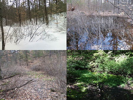 Vernal pools are those wetlands and temporary ponds that typically have ponded water only part of the year. Because the pools are temporary, they provide critical habitat for certain wildlife to breed and complete their life cycle. Many of the animals that breed in vernal pools live in the upland areas around the pool during the non-breeding season. When pools dry, wood frogs migrate to forested upland areas that are as much as 1,000 to more than 2,000 feet from their breeding pools. Mole salamanders will migrate to forested uplands that are 1,000 feet from their breeding pools. Vernal pools are a resource protected from unregulated alteration under the NHDES Wetlands law and rules. The rules provide definitions of vernal pool, primary vernal pool indicators and secondary vernal pool indicators.
Typically, a vernal pool:
- Forms in a shallow depression or basin.
- Holds water for at least 2 continuous months following spring ice-out.
- Cycles annually from flooded to dry conditions, although the hydroperiod, size, and shape of the pool might vary from year to year.
- Has no permanently flowing outlet.
- Lacks a viable fish population.
- Supports one or more primary vernal pool indicators, or three or more secondary vernal pool indicators.
Look at the USC Vernal Pool Field Guide for information on the many species considered vernal pool indicators.
The following documents can be used to identify and document vernal pools
- Vernal Pool Identification Field Cards
Northeast Vernal Pool Indicator Species - Vernal Pool Documentation Manual – Identification and Documentation of Vernal Pools in NH
A standardized approach to locating, identifying and documenting vernal pool habitat and indicator species. - NH Vernal Pool Documentation Form to collect appropriate information necessary to document the presence of a vernal pool or potential vernal pool in New Hampshire.
- UNH Cooperative Extension – Vernal Pools
Importance, vulnerabilities, wildlife and stewardship guidelines for vernal pools in NH - Reptiles and Amphibians – Report Your Sightings!
NHFG’s Reptile and Amphibian Reporting Program (RAARP) - USACE – Vernal Pools
Guidance on avoiding and minimizing impacts to vernal pools and complying with the Corps vernal pool requirements