


Wetlands and Stream Crossings FAQs
Providing detailed information about wetlands and shoreland regulations.
- What is a wetland?
- What areas are regulated under New Hampshire Wetlands Law?
- What are the wetlands setbacks?
- What activities require a wetlands permit?
- How do I determine temporary and permanent wetland impacts?
- How long is a wetlands permit valid?
- Can a wetlands permit be extended?
- What is avoidance and minimization?
- What is mitigation and when is it required?
- What is a Priority Resource Area (PRA)?
- When do I need a pre-application meeting?
- What is the highest observable tide line?
- What is the developed upland?
- Can I cut or remove trees and vegetation within a wetland?
- What are Best Management Practices (BMPs)?
- What is the Natural Heritage Bureau (NHB)?
- What does "grandfathered" mean?
- What is considered a "structure"?
- What is bankfull width and bankfull depth?
- What is flood-prone width?
- What is entrenchment ratio?
- What is sinuosity?
- What is bankfull cross-sectional area?
- What is width to depth ratio?
- What is a wetland?
-
An area that, either through surface water or groundwater, is wet enough and wet for a long enough period of time, to support a predominance of vegetation that grows in saturated soil conditions. In order for an area to be deemed a wetland, all three (3) of the following must be present:
- Hydric Soils – Soils that are saturated or flooded during the growing season sufficient to produce anaerobic conditions in the upper soil layers.
- Hydrophytic Vegetation – Greater than 50% of the vegetation present is adapted for life in saturated soil conditions.
- Hydrology – Evidence exists that demonstrates the soils in the area are inundated with water either permanently or periodically throughout the growing season.
Examples of wetlands include, but are not limited to: swamps, bogs, marshes, forested wetlands, wet meadows and vernal pools.
Helpful Documents:
NHDES does not provide wetland delineation services. To confirm the presence of a wetland on your property, we recommend contacting a NH Certified Wetland Scientist (CWS).
- What areas are regulated under New Hampshire Wetlands Law?
-
A Wetlands Permit from the NHDES Wetlands Bureau is required for excavating, removing, filling, dredging or constructing structures within the following areas:
- Wetlands, such as forested, scrub-shrub, emergent wetlands, marshes, wet meadows and bogs.
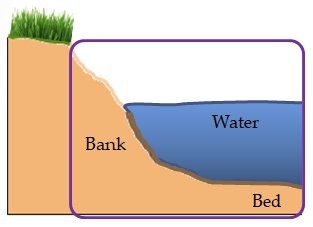
- Surface waters, including the beds and banks of streams, rivers, lakes, ponds and tidal areas.
- Upland Tidal Buffer Zone, which is the area extending landward 100 feet from the highest observable tide line. This area can contain wetlands, transitional areas, developed and undeveloped upland.
- Prime Wetland Buffer, which is the duly-established, 100-foot upland buffer surrounding wetlands that have been municipally designated as Prime Wetlands and, at the time of their designation, a 100-foot upland buffer was required.
- Sand Dunes, which is a hill or ridge of sand piled up by the wind and commonly found on the seacoast.
- What are the wetlands setbacks?
-
Under NH Wetlands Law, RSA 482-A, there are no setbacks. Many municipalities have more stringent standards and include wetlands buffers and setbacks. Several specific resource types in New Hampshire have buffers (added levels of protection) and, under RSA 485-A, there are setbacks when installing new septic systems.
- Prime Wetlands: Under RSA 482-A:15, several municipalities in New Hampshire have designated Prime Wetlands. Some municipally-designated Prime Wetlands have a 100-foot Prime Wetland buffer zone. Please use the NHDES Wetlands Permit Planning Tool to determine if a municipality has designated Prime Wetlands with or without 100-foot buffer zones.
- Tidal Buffer Zone: The area extending landward 100 feet from the highest observable tide line. This area can contain wetlands, transitional areas, and developed and undeveloped upland.
- Waterbodies Protected under the Shoreland Water Quality Protection Act (SWQPA): Under RSA 483-B, all lakes, ponds and impoundments greater than 10 acres, all 4th order and greater streams and rivers, all designated rivers and designated river segments, and all waterbodies subject to the ebb and flow of the tide are protected.
Under the SWQPA, there is a 50-foot primary structure setback and a 20-foot accessory structure setback for those accessory structures that are not water-access structures.
There are also limitations on removing vegetation adjacent to protected waterbodies and this is explained within the Vegetation Management for Water Quality fact sheet.- Septic Systems: Under RSA 485-A, the NHDES Subsurface Systems Bureau requires that new septic systems be installed at least 75 feet from wetlands that contain very poorly drained soils and 50 feet from wetlands having poorly drained soils.
When installing septic systems within the protected shoreland, refer to these setbacks .
- What activities require a wetlands permit?
-
A permit from the NHDES Wetlands Bureau is required for excavating1, filling2, dredging3 and removing or constructing structures within areas jurisdictional under wetlands law (RSA 482-A).
Examples of common activities that require a NHDES Wetlands Permit include, but are not limited to:
- Construction of roadways or driveways over wetlands or watercourses.
- Installing new culverts over wetlands or watercourses.
- Driving through wetlands and/or removing vegetation when soils are rutted or the roots of vegetation are disturbed.
- Maintenance, repair or replacement of culverts, bridges, dams and other structures.
- Logging activities within wetland areas.
- Trail construction over wetlands or watercourses.
- Utility inspection, maintenance and repair (electric, gas, water) within wetland areas.
- Pond construction and maintenance dredging.
- Beach construction or replenishment of beach sand.
- Constructing and repairing boat houses.
- Constructing and repairing breakwaters.
- Construction, modification and repair of docking structures.
- Installing watercraft lifts.
- Construction repair or modification of any retaining wall within or adjacent to surface waters or wetlands.
- Removing sand dune vegetation.
1 Excavating: digging, removing, or forming a cavity or a hole in an area within department's jurisdiction.
2 Filling: placing materials in or on a wetland, surface water body, bank or otherwise in or on an area within the jurisdiction of the department.
3 Dredge: to dig, excavate, or otherwise disturb the contour or integrity of sediments in the bank or bed of a wetland, a surface water body, or other area within the department's jurisdiction. - How do I determine temporary and permanent wetland impacts?
-
Temporary wetland impacts result from activities in jurisdictional areas that will be fully restored to pre-construction grades and conditions when the authorized work has been completed.
Temporary impacts often include, but are not limited to: areas excavated for burying utility lines; ruts caused by heavy machinery that are smoothed and restored when the work is completed; installing temporary equipment access ways; and installing temporary erosion and sedimentation controls.
Permanent wetland impacts result from activities in jurisdictional areas that are intended to remain, or that do remain, after the activities have ceased. These include jurisdictional areas that are altered, excavated, dredged or filled to a state that is irreversible. Permanent wetlands impacts include, but are not limited to: fill associated with a wetland or stream crossing, bridge abutments, culverts and excavation associated with ponds, ditches and channels.
- How long is a wetlands permit valid?
-
With the exception of Forestry Statutory Permit-by-Notifications, Small Motor Mineral Dredging Permits, and 10-year wetlands permits issued to repair or replace shoreline structures, wetlands permits are valid for 5 years.
- Forestry Statutory Permit-by-Notifications are valid for two years.
- Small Motor Mineral Dredging permits expire at the end of the calendar year in which they are issued.
- Wetlands permits issued to repair or replace shoreline structures to maintain their safety and integrity such as, but not limited to: docks, sea walls, breakwaters, riprap, access ramps and stairs that are damaged by storms or ice are valid for 10 years provided any work performed after the initial permitted work is completed meets the following conditions:
- The original permit has not been revoked or suspended without reinstatement.
- All structures are repaired or replaced to the original permitted location and configuration.
- All significant work is reported to the department in accordance with the reporting requirements for the original permit.
- Can a wetlands permit be extended?
-
With the exception of Forestry Statutory Permit-by-Notifications, Small Motor Mineral Dredging Permits, and 10-year wetlands permits issued to repair or replace shoreline structures, a single wetland Permit Extension not exceeding 5 years may be granted, provided the applicant demonstrates all of the following:
- The permit for which the extension is sought has not been revoked or suspended without reinstatement.
- The extension does not violate a condition of law (RSA 482-A) or rule Env-Wt 100-900.
- The project is proceeding towards completion in accordance with plans and other documentation referenced by the permit.
- The applicant proposes reasonable mitigation measures to protect the public waters of the state from deterioration during the period of extension.
- The wetland delineation is still valid pursuant to NH Administrative Rule Env-Wt 406.01(b).
- What is avoidance and minimization?
-
Permit applications are required to demonstrate that all proposed impacts to jurisdictional resources such as wetlands will be "avoided and minimized" to the greatest extent practicable.
Avoidance means not impacting jurisdictional areas at all, if an alternative option would have less impact and not have other significant adverse environmental consequences. An example of avoidance is using an available upland area to construct a driveway for a proposed single-family residence to avoid constructing the driveway through a wetland.
If an applicant cannot avoid impacting jurisdictional resources, impacts must be minimized to the greatest extent practicable.
Minimization as used here means reducing adverse impacts to jurisdictional areas such as wetlands. For example, if a wetland crosses an entire property, and an applicant cannot access the buildable portion of the lot without crossing the wetland, minimization measures could include:
- Constructing the crossing through the narrowest portion of the wetland.
- Limiting the number of wetland or stream crossings to the minimum required to access the buildable portion of the lot.
- Narrowing the driveway and side slopes through the wetlands to reduce the amount of fill required.
- Installing culverts to help support hydraulic connectivity and aquatic organism passage.
For more information on how to avoid and minimize impacts for a proposed project, please consult our Wetlands Permitting; Avoidance, Minimization, and Mitigation fact sheet and the 2019 Wetlands Avoidance and Minimization Best Management Practices Manual.
- What is mitigation and when is it required?
-
Mitigation is a way to ensure a project does not create a net loss of wetland functions and values. NHDES requires mitigation for projects that:
- Will permanently impact a Priority Resource Area (PRA).
- Will permanently impact 10,000 square feet or more of non-tidal wetlands.
- Will permanently impact tidal surface waters, tidal wetlands, the tidal buffer zone, or sand dunes, or any combination thereof, unless otherwise specified in Rule Env-Wt 605.03(b).
- Will alter the course of or disturb 200 linear feet or more of an intermittent or perennial non-tidal stream or river channel or its banks.
- Involve the construction of a new Tier 3 or Tier 4 stream crossing unless otherwise specified in the Stream Crossing Rules, Env-Wt 900.
- Involve the construction of a pond with more than 10,000 square feet of impact in a wetland or surface water.
- Involve the installation of accessory docking structures or the construction of new shoreline structures and breakwaters, or includes such work in combination with other qualifying criteria, provided the resulting dock surface area of all shoreline structures on the frontage is 2,000 or more square feet.
To learn more about wetlands mitigation, visit the Wetlands Mitigation Program Page.
- What is a Priority Resource Area (PRA)?
-
Priority Resource Areas (PRAs) are jurisdictional areas that are considered to contain high-value wetland resources that warrant additional protections. In order for a wetland to be considered to be a PRA, it must meet one or more of the following criteria:
- Has documented occurrences of protected species or habitat.
- Is a bog.
- Is a floodplain wetland contiguous to a tier 3 or higher watercourse.
- Is a designated prime wetland.
- Is duly-established 100-foot buffer of a designated prime wetlands.
- Is a sand dune, tidal wetland, tidal water, or undeveloped tidal buffer zone.
The presence of a PRA within the vicinity of a proposed project may have an effect on project classification or mitigation requirements. Please read the Priority Resource Area fact sheet for more information.
- When do I need a pre-application meeting?
-
Pre-application meetings are necessary when a project requires mitigation or if a proposed project involves 10,000 square feet or more of potential impacts to wetlands. Please email Rebekah.J.Webb@des.nh.gov for scheduling. Pre-application meetings typically book several weeks in advance. Note that timing will depend on NHDES staff schedules as well as other state and federal agencies if applicable.
Pre-application meetings are also required for streamlined processing of some Minimum Impact projects. Please review the project classification rules that pertain to your project type in Env-Wt 500.
For other project types, pre-application meetings are optional. To schedule one, please contact the applicable Wetlands Regional Reviewer.
- What is the highest observable tide line?
-
The highest observable tide line is a line defining the farthest landward limit of tidal flow, not including storm events, that can be recognized by indicators such as the presence of a strand line of flotsam and debris, the landward margin of salt tolerant vegetation, or a physical barrier that blocks farther inland flow of the tide.
- What is the developed upland?
-
Developed upland is an upland area on a lot within the tidal buffer zone or sand dune where:
- The natural soil and vegetation characteristics on more than 50% of the lot have been legally altered and have not returned to a natural state.
- If the lot is in a tidal buffer zone, developed lots abut at least 2 sides of the lot.
- If the lot is in a dune slack area, the lot is surrounded on 4 sides by developed lots or roadways.
- If the lot is in a dune, the back side of a fore dune is within the line of encroachment and the lot is surrounded on 3 sides by developed lots or roadways.
- At least one of the following is true:
- The lot has legally been filled or excavated in whole or in part, whether prior to jurisdiction or pursuant to a permit or other authorization.
- The lot contains at least one paved or graded area that is, has been, or will be used for vehicular parking or traffic.
- One or more residential or commercial buildings has been built on the lot.
- Can I cut or remove trees and vegetation within a wetland?
-
Mowing and cutting of vegetation, including trees, within wet meadows or forested wetlands, such as red maple swamps, hemlock swamps, or white pine swamps, is conditionally authorized by NH Administrative Rule Env-Wt 309.02(a), provided the following conditions are met:
- The roots of the vegetation are not disturbed.
- The ground is frozen or sufficiently dry to avoid making ruts.
- The project is not located in a bog, designated prime wetland, duly-established 100-foot buffer, marsh, or tidal buffer zone.
There are limitations on removing vegetation adjacent to many surface waters of the state and this is explained within the Vegetation Management for Water Quality fact sheet.
Always check with local town ordinances because they are often more stringent than state standards.
- What are Best Management Practices (BMPs)?
-
BMPs are publications created to promote a better understanding of valuable resources and they provide methods for minimizing impacts to them. Visit the Wetlands Technical Assistance page for a list of wetland BMP resources.
- What is the Natural Heritage Bureau (NHB)?
-
The Natural Heritage Bureau (NHB) maintains data on known locations of rare species and exemplary natural communities. Please use their DataCheck Tool as part of planning proposed projects that require NHDES permits. It will help you confirm the presence or absence of protected species in or near your proposed project area, as well as recommended next steps if you find that any are present.
- What does "grandfathered" mean?
-
"Grandfathered" status, in a wetland context, means a structure was in place before its permitting jurisdiction took effect under RSA 482-A:3, I. or its predecessor statute, RSA 483-A:1, I. More information on this topic is described in state rules in Env-Wt 103.58.
To be “grandfathered” as used here, a structure must meet all of the following criteria:
Construction / impact date:
- In and adjacent to tidal waters and wetlands - before June 22, 1967.
- In and adjacent to non-tidal waters and wetlands - before June 2, 1969.
- Seasonal docking structures in tidal or non-tidal waters - before September 4, 1978.
- In duly-established 100-foot buffers - date of designation of associated prime wetlands.
Structure specifics since initial construction and installation:
- Has remained unaltered in location, size and configuration, or is a replacement structure as defined in state rule Env-Wt 104.06.
- Has not been abandoned as defined in state rule Env-Wt 102.02.
- Is consistent with the public’s right to reasonable use of public waters, as established in state case law.
- Is not built on land created by the unauthorized filling of public waters.
- What is considered a "structure"?
-
A structure, as defined in RSA 482-A:2, IX, means something installed, erected or constructed in a fixed location. Examples of structures include, but are not limited to: fences, docks, breakwaters, posts, piles, buildings, bridges, culverts and walls.
Structures do not include, provided their construction does not require any regrading or re-contouring of a waterbody’s shoreline and they're not constructed over a waterbody, benches, landings with dimensions no larger than 10 feet wide by 10 feet long, or stairs not wider than 6 feet.
- What is bankfull width and bankfull depth?
-
Bankfull width is the distance between the left and right stream banks at bankfull stage (channel forming flow, which is typically the 1.5 to 2-year flood frequency event).
Bankfull depth is the vertical depth of a river/stream channel measured from the bed to the estimated water surface elevation required to completely fill the channel (bankfull width). If water depth exceeds the bankfull depth, then flow would enter onto the floodplain or exit the river/stream channel.
Maximum bankfull depth is measured from the deepest part of the channel (thalweg) to the water surface elevation at bankfull discharge.
Mean bankfull depth is the average depth in a cross-section at bankfull discharge. The bankfull depth corresponds with the start of a floodplain, which can be characterized by the following:- Topography – usually noted as a berm or a break in the slope from the channel bank to a flatter surface.
- Vegetation – a change from bare surfaces or water tolerant species to semi-water tolerant or upland species.
- Sediment Texture – change in the size distribution of sediments.
In cases where multiple channels exist, bankfull depth is the average depth of all the river/stream channels along a cross section.
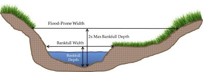
- What is flood-prone width?
-
Flood-prone width is measured at the water surface elevation that corresponds to twice the maximum bankfull depth.
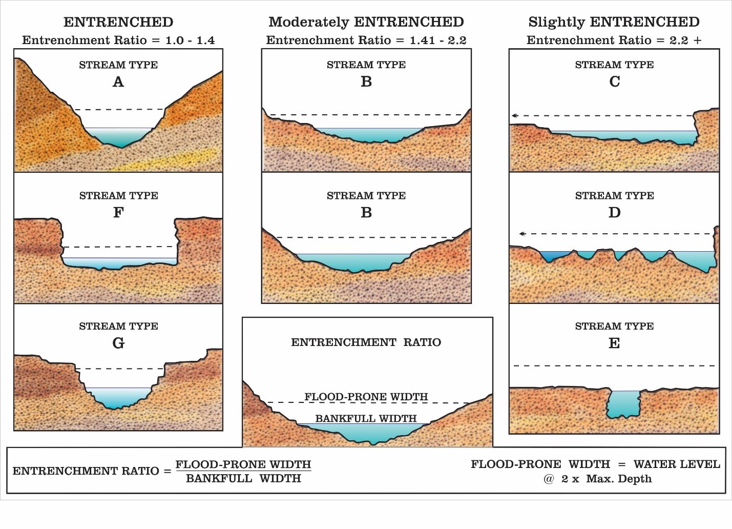
- What is entrenchment ratio?
-
Entrenchment ratio is calculated as the flood-prone width divided by the bankfull width. Entrenchment ratio is the vertical containment of a river as seen by the relationship between the channel (within the bankfull width) and the surrounding floodplain (within the flood prone width). The lower the ratio, the more entrenched a channel is. Entrenchment ratio helps determine the vertical containment of the river, which should be considered when designing a stream crossing structure.
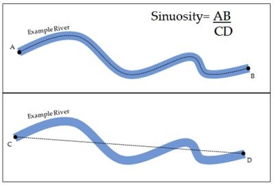
- What is sinuosity?
-
Sinuosity is a measure of a river's tendency to meander, move throughout a flood plain, or deviate from the shortest possible path. It is expressed as the ratio of actual channel length (AB) to straight-line valley length (CD). The higher the ratio, the more sinuous the stream is.
- What is bankfull cross-sectional area?
-
Bankfull cross-sectional area is the bankfull width multiplied by the mean bankfull depth.
- What is width to depth ratio?
-
Width to depth ratio is the ratio of the bankfull width divided by the mean bankfull depth.