What is the Shoreland Water Quality Protection Act?
The Shoreland Water Quality Protection Act (RSA 483-B) establishes buffers known as “protected shoreland”, located along public waters. Within the protected shoreland, the Shoreland Water Quality Protection Act (SWQPA) regulates certain activities such as a lot subdivision, land development, and vegetation management, among other things.
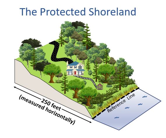
Where is the protected shoreland?
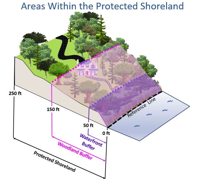
The protected shoreland is within 250 feet of the reference line of public waters. The protected shoreland are those lands located within 250 feet of the reference line of public waters; this 250 feet is measured from the reference line horizontally as measured from a bird’s eye view. Public waters include:
Lakes, ponds and impoundments greater than 10 acres;
Coastal waters, being all waters subject to the ebb and flow of the tide, including the Great Bay Estuary and associated tidal rivers, tidal marshes, rivers, and estuaries.
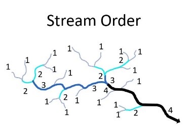
What is a “fourth order stream” and how do I determine if a stream or river is “fourth order or higher”?
Representation of the stream order for a watershed. Stream order is a classification system for all streams and rivers. The smallest streams which have no other streams feeding them, are first order streams. When two first order streams merge, they form a second order stream. Continuing the ordering system, when two second order streams merge, a larger, third order stream is formed, and so on. In New Hampshire, all fourth Order and greater streams and rivers are protected under the Shoreland Water Quality Protection Act (SWQPA). The SWQPA also applies to smaller rivers – first, second, and third order – that are designated under the New Hampshire Rivers Management and Protection Program.
What is a Designated River?
A designated river is a river that is protected for its outstanding natural and cultural resources in accordance with RSA 483, The Rivers Management & Protection Act. The Interactive Web Map of Designated River Corridors may be used to determine if a project is within ¼ mile of a designated river, including some lakes or ponds that are dammed rivers.
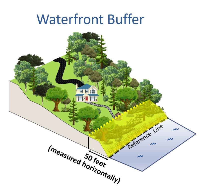
Where is the waterfront buffer?
The waterfront buffer is the area of the protected shoreland located within 50 feet of the reference line of public waters. The waterfront buffer is the area of the protected shoreland located within 50 feet of the reference line elevation of public waters, measured horizontally.
Where is the reference line located?
The reference line is the edge of the water body at its full volume, from which setbacks, such as the limits of the protected shoreland, are determined. The type of public waters determines the location of the reference line:
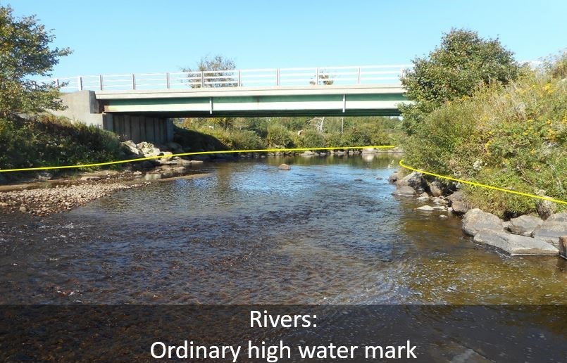
An example of the location of the reference line for a river is indicated by the yellow line. For year-round flowing waters of fourth order or higher and Designated Rivers, the reference line is the ordinary high water mark. The ordinary high water mark is the line on the shore, running parallel to the main stem of the river, established by the fluctuations of water. It is indicated by physical characteristics such as a clear, natural line impressed on the immediate bank, shelving, changes in the character of soil, destruction of terrestrial vegetation, the presence of litter and debris, or other appropriate means that consider the characteristics of the surrounding areas. Where the ordinary high water mark is not easily discernible, the ordinary high water mark may be determined by NHDES.
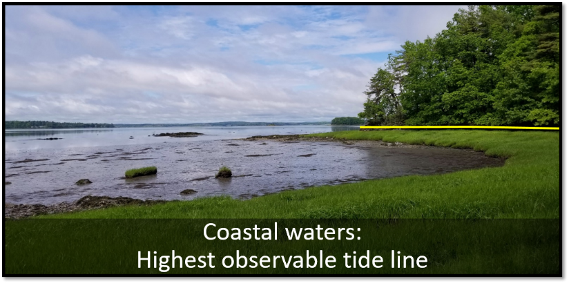
An example of the location of the reference line for coastal waters is indicated by the yellow line. For coastal waters, the reference line is the highest observable tide line, which means a line defining the furthest landward limit of tidal flow. This does not include storm events. It can be recognized by indicators such as the presence of a strand of trash and debris, the landward margin of salt tolerant vegetation, or a physical barrier that blocks further flow of the tide.
Where is the woodland buffer?
The woodland buffer is the area of the protected shoreland located within 150 feet of the reference line of public waters. The woodland buffer is the area of the protected shoreland located within 150 feet of the reference line of public waters, measured horizontally. The woodland buffer includes the waterfront buffer, which is the area located within 50 feet of the reference line.
What is a primary structure?
A primary structure is one that is central to the fundamental use of the property and is not accessory to the use of another structure on the same premises. Primary structures on residential lots are typically houses and include all attached decks. There can be multiple primary structures on a single lot. A structure means anything constructed or erected for the support, shelter or enclosure of persons, animals, goods, or property of any kind, with a fixed permanent location on or in the ground. The function and use of the structure in the context of the overall use of a given property is what determines whether or not it meets the definition of “primary structure.”
What is a nonconforming structure?
Nonconforming structure means a structure that, either individually or when viewed in combination with other structures on the property, does not conform to the provisions of the Shoreland Water Quality Protection Act.
An example of a nonconforming structure would be a house, including all attached decks, that is partially or completely located within 50 feet of the reference line of public waters, and therefore does not meet the minimum distance from the reference line established by law for primary structures.
Can I repair or expand my house if it is a nonconforming structure?
Yes, nonconforming structures may be repaired or expanded, with some restrictions. In many cases, nonconforming structures can be repaired without a shoreland permit. Maintenance, repair, and modifications including vertical expansion of existing, legal, nonconforming primary structures do not require a shoreland permit if the following conditions are met:
There is no expansion of the footprint of the interior, living space of the structure, including all closed porches.
The project does not require excavation or fill.
Projects involving changes in the dimension of an attached deck require a shoreland impact permit or permit by notification. New decks may be added to nonconforming primary structures and existing decks may be expanded, provided they extend no more than 12 feet towards the reference line from the surface of the primary structure to which they are attached.
Projects that involve expanding the footprint of interior living space of existing, legal, nonconforming primary structures require a shoreland permit as well as a proposal to make the property more nearly conforming. These projects include enclosing an open porch or converting a deck to living space. Please note that the enclosure of an open porch or deck located between a nonconforming structure and the reference line would be prohibited by RSA 483-B:9, II, (b).
Always check with local town ordinances as many towns have restrictions that are more stringent than the Shoreland Water Quality Protection Act.
What is a water access structure and what are water access structure limitations?
“Water access structure” means a structure without a roof or cover that typically would be an accessory structure under RSA 483-B and that, as a matter of operational necessity, is located adjacent to the shoreline because its purpose is to provide a means of entry to a surface water for swimming and similar water-related recreational activities other than boating or a location for the direct observation of swimmers or other individuals engaged in water-related recreational activities. The term includes beaches, decks, and patios, but does not include stairs, steps, or docking structures. The size, location, and construction of water access structures are regulated. For more information, please refer to the Shoreland Accessory Structure Fact Sheet.
What is considered the footprint of a structure?
For the purpose of applying RSA 483-B:11, the footprint of a nonconforming primary structure is the area of land surface that lies directly beneath the limits of the exterior walls, whether the structure rests directly on the ground or is raised above the ground surface.
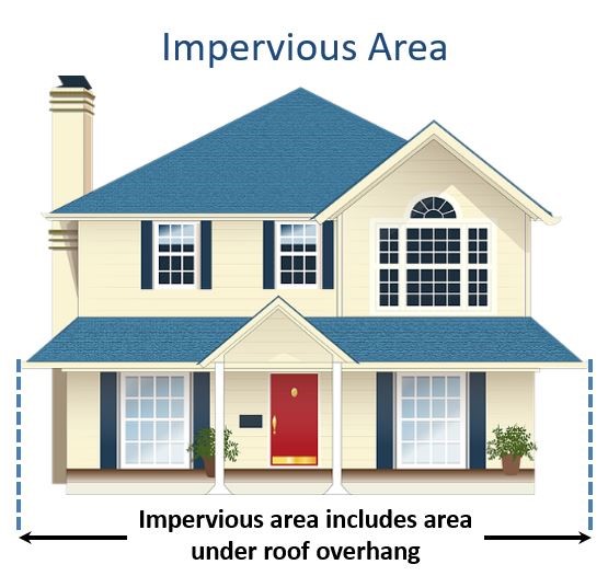
For all other purposes, such as when determining the footprint of a structure for the purpose of calculating impervious area, the footprint is the area outlined by the vertical projection of the impervious surface onto the ground surface where it is or will be located. For instance, the structure's roof overhang is considered when determining the impervious area of a structure.
What is an 'impervious area'?
The impervious area of a house includes all roof overhangs.An impervious area is any modified surface that cannot effectively absorb or infiltrate water. Examples of impervious areas include, but are not limited to, roofs and decks, and unless designed to effectively absorb or infiltrate water, also includes: patios; paved, dirt, or gravel driveways and parking areas; and walkways.
What activities DO NOT require a shoreland permit?
Many activities within the protected shoreland have been identified as not requiring a shoreland permit because they do not constitute construction, excavation, or fill, or are exempt by statute or rule. These activities include, but are not limited to:
The following vegetation management activities:
Trimming, pruning, and thinning branches to protect structures, maintain clearances, and provide views (refer to the Vegetation Management for Water Quality Fact Sheet for restrictions pertaining to vegetation management).
Maintaining legally existing altered areas, such as mowing lawns, raking leaves and pine needles, mulching landscaped areas, or haying fields.
Planting one or more trees within legally existing open areas more than 50 feet from the reference line with mechanized equipment.
Planting non-invasive vegetation within legally existing altered areas using hand-held tools.
Maintaining legally existing gardens using hand-held tools.
Using hand tools to remove invasive species or other noxious or harmful plants, such as poison ivy, including the root systems, provided that any area exceeding ten square feet without vegetation is replanted with non-invasive, non-harmful species.
The following activities involving the installation, construction, repair, or modification of structures:
Installing readily moved items such as picnic tables, lawn chairs, and swing sets. This does not include impervious playground-like areas with rubber mats and mulch.
Constructing or installing a fence using hand tools.
Placing a single accessory structure, such as a shed, at least 50 feet from the reference provided that:
The footprint of the structure is less than 150 square feet;
The construction or placement of the structure will not result in excavation or fill using mechanized equipment;
The structure will not be heated;
The structure will not have electricity or plumbing; and
The structure will not be used as living space for humans.
Maintaining, repairing or modifying an existing driveway, including repaving, provided that there is no change in impervious area or footprint.
Maintaining, repairing or modifying a legally-existing primary structure that does not:
Require, or result in, the alteration of previously unaltered areas;
For existing, legal, nonconforming structures that do not meet the 50-foot primary structure setback from the reference line, extend living space closer to public waters or increase living space within the waterfront buffer. An example of an activity that would increase living space is to enclose an open porch;
Result in an increase in loading to an onsite sewage disposal system; or
Require, or result in, any excavation or fill within the protected shoreland.
Maintaining, repairing or modifying a legally-existing accessory structure that does not:
Require, or result in, the alteration of previously unaltered areas;
Result in an increase in loading to an onsite sewage disposal system;
Require, or result in any excavation or fill within the protected shoreland; or
Result in a violation of Env-Wq 1405, if it is located within the waterfront buffer.
Modifying an existing structure that minimally changes the outside dimensions of the structure, such as installing a skylight or dormer or putting new siding over old siding, provided the project does not require excavation or require additional fill.
Installing private water facilities, such as a well, including the trenching associated with connecting the well to a residential dwelling.
The following activities involving forest management, forestry, timber harvesting and agriculture:
Forest management that is not associated with shoreland development or land conversion that is conducted in compliance with RSA 227-J:9.
Timber harvesting activities permitted in accordance with RSA 485-A:17, IV.
Forestry conducted by or under the direction of a water supplier for the purpose of managing a water supply watershed.
Agriculture performed in accordance with best management practices, as specified in RSA 483-B:3, III, and RSA 483-B:9, V.
The following activities related to wastewater disposal and subdivisions:
Digging test pits to determine suitability for wastewater disposal under RSA 485-A:29 relating to subdivisions or septic systems, provided:
There is no disruption of groundcover within 50 feet of the reference line; and
No test pits are dug within 75 feet of the reference line unless required in order to evaluate eligibility for replacement under Env-Wq 1003.10.
Replacing a failed septic system, either in-kind as specified in Env-Wq 1003.10 or under a new approval, provided there is no increase in sewage loading from the structure(s) served by the system.
Using hand-held tools, whether motorized or not, such as augers or tile spades, to install monitoring wells, piezometers, and flow meters, to evaluate site conditions as necessary for the submittal of information required for a permit application under RSA 485-A:29 relating to subdivisions or septic systems.
And the following additional activities:
Placing stepping stones, provided no root systems are removed to accommodate their placement.
Replacing utility poles or guy wires using mechanized equipment, provided that appropriate siltation and erosion controls are used and all temporary impacts are restored.
Using hand-held tools, whether motorized or not, such as augers or tile spades, to install monitoring wells, piezometers, and flow meters:
To evaluate site conditions as necessary for the submittal of information required for a permit application under RSA 482-A relating to wetlands, or RSA 485-A:17 relating to alteration of terrain;
For educational or research purposes; or
To monitor hydrology.
Hand-removing or using hand tools to remove rocks and stones beyond 50 feet of the reference line of public waters.
Commercial or industrial redevelopment in accordance with RSA 485-A:17.
Activities required to abate an imminent threat to public safety or public health or to stabilize property during or immediately following an emergency, provided the procedures specified in Env-Wq 1407 are followed.
Can I use fertilizer in the protected shoreland?
Fertilizer cannot legally be applied to vegetation or soils located within 25 feet of the reference line of any public waters. Beyond 25 feet, slow or controlled release fertilizer may be used, but must be applied by horticultural professionals who have a pesticide application license issued by the New Hampshire Department of Agriculture.
Slow or controlled release fertilizer means fertilizer that is guaranteed, as indicated on the package label, to contain:
At most 2 percent phosphorous, and
A nitrogen component which is contains at least 50% slow release nitrogen.
Are there regulations on the location of septic systems within the protected shoreland?
Yes. All new leaching portions of new septic systems are subject to minimum distances (setbacks) from the reference line. The setbacks vary according to soil type and the type of public waters:
Adjacent to ponds, lakes, estuaries and the open ocean:
Where the receiving soil down gradient of the leaching portions of a septic system is a porous sand and gravel material with a percolation rate equal to or faster than two minutes per inch, the leaching portions of new septic systems must be at least 125 feet from the reference line.
For soils with restrictive layers within 18 inches of the natural soil surface, the leaching portions of new septic systems must be at least 100 feet from the reference line.
For all other soil conditions, the leaching portions of new septic systems must be at least 75 feet from the reference line.
Adjacent to rivers and streams: The setback for a septic system must be at least 75 feet.
The placement of all septic tanks and leaching portions of septic systems for replacement systems must comply with the setbacks described above, to the maximum extent feasible.
Do I need a shoreland permit to install or repair a septic system?
Installation of new septic systems on previously undeveloped lots and installation of replacement septic systems that must occur as a result of proposed increases in sewerage loading from the existing structure(s) requires a shoreland impact permit.
If an existing septic system has failed and the septic system can be replaced in-kind or under a new approval, a shoreland impact permit is not required if no increase in sewerage loading will be served by the system.
What are temporary impact areas?
Temporary impacts are areas impacted by regrading, excavation, and filling that only temporarily expose the ground and underlying soils to the erosive forces of stormwater. Temporary impacts often include, but are not limited to:
all areas excavated and/ or regraded when preparing a site for a new construction.
All excavation and regrading that occurs beyond the limits of a new foundation.
The impact area associated with installing a new septic system.
The impact area associated with installing a temporary access way.
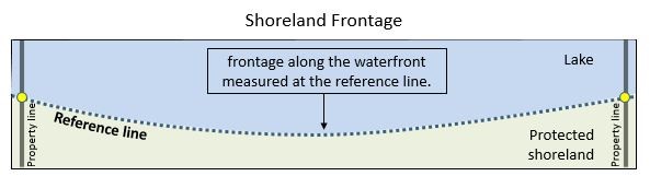
How is shoreland frontage determined?
The dashed blue line represents the length of the shoreland frontage.Shoreland frontage is measured along the waterfront at the reference line, between the property lines of a lot. In other words, it is the length of the reference line between the property lines.
Do I need a shoreland permit if I have a wetlands permit?
Impacts (excavation, fill, or construction) covered under a wetlands permit do not require a separate shoreland permit for the same impacts. However, a separate shoreland permit is required for any impacts within the protected shoreland not covered under a wetlands permit. For example, the construction of a beach within the protected shoreland covered under a wetlands permit does not require a separate shoreland permit, but temporary and permanent impacts within the protected shoreland to access the beach would require a separate shoreland permit.