


Instream Flow
Ensuring that New Hampshire’s 19 designated rivers have enough water for both people and aquatic life.
The Instream Flow Program ensures that rivers continue to flow in spite of the uses and stresses that people put on them. Under natural conditions, rivers flow freely with source waters coming from precipitation via lakes, ponds, wetlands, small streams and groundwater. Under human influences, however, river dynamics can change drastically. People frequently withdraw large amounts of water for drinking and irrigation directly from rivers, as well as from the sources that supply the rivers, particularly lakes and groundwater. Land use changes can result in faster runoff and changes to the stream structure. Many rivers have dams that restrict the amount and timing of water flowing downstream. In addition, the loss of wetlands to land development reduces the amount of water that would normally augment rivers during dry periods. These changes in stream flow can impair river habitat. For information regarding how instream flow affects dams and their impoundments, please see Instream Flow Management: Implications for Lakes. The Instream Flow Program operates within the New Hampshire Rivers Management and Protection Program statute, Section 9-c (RSA 483:9-c) and in accordance with Administrative Rule Env-Wq 1900.
The program determines the seasonal flows necessary to support both natural aquatic habitats and human uses and then works with water users and dam owners to ensure that their water needs are met while maintaining the protected flows during periods of unusually low flow, even during droughts. The program annually performs a wide range of field activities to collect the environmental data necessary to develop protected instream flow values and evaluate the success of instream flow management; the program’s 2024 Work Plan summarizes those field activities.
Currently, two designated rivers, the lower Lamprey and Souhegan Rivers, are actively managed under the Instream Flow Program. In addition, protected instream flows have been established for the designated Cold and Warner Rivers and are being developed for the Ashuelot River.
Protected Instream Flow Studies and Plans
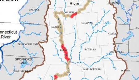
The protected instream flow of the Ashuelot River has been completed and the study report is being written. The draft Protected Instream Flow Study Reports for the Cold and Warner Rivers have been published and the criteria have been established as water quality criteria. Protected instream flows are criteria that define a stream flow pattern and maintain water for instream public uses and aquatic wildlife and meet water quality standards. NHDES is currently working with water users and dam owners along these rivers to determine water use needs and current practices to develop Water Management Plans that balance human needs with the needs of aquatic life identified by each protected instream flow study. A public hearing on each draft Water Management Plan will be scheduled when they are completed. For information about how dam management for instream flow can affect lakes, see The New Hampshire Instream Flow Program fact sheet.
- Ashuelot River Study
- Cold River Study
- Isinglass River Study
- Pemigewasset River Study
- Warner River Study
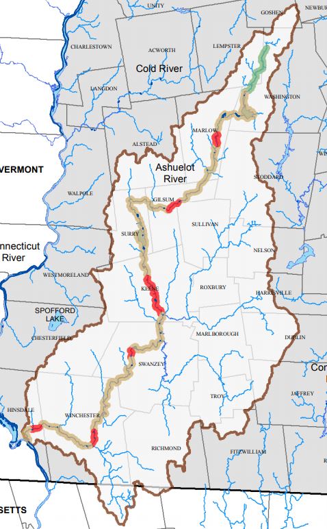 The protected instream flow study of the Ashuelot River began in 2021 and fieldwork was completed in 2022. The draft Protected Instream Flow Study Report is estimated to be ready for public review and release in Summer 2024 and the draft Water Management Plan for the Ashuelot River will be developed thereafter. Please watch this space for notifications.
Real Time Water Data
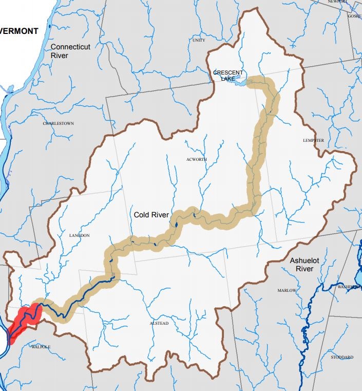 The Cold River was the subject of a Protected Instream Flow Study Report between 2020 and 2021. On January 25, 2022, NHDES’ Commissioner established the protected instream flow values included in the report as water quality standards, in accordance with Administrative Rule Env-Wq 1904. The draft Cold River Instream Flow Water Management Plan Report and appendices are now available for public review. An informational meeting (Cold River Water Management Plan Information Meeting Recording 6/5/24) was held June 5, 2024 to preview the report. A public hearing will be held June 20, 2024 to receive comments on the report. The hearing will start at 6:00 PM at the Alstead town hall at 9 Main Street, Alstead, NH. Public comments will be taken from June 20 through July 22 at 4:00 PM.
Current Cold River Instream Flow Conditions
Real Time Water Data
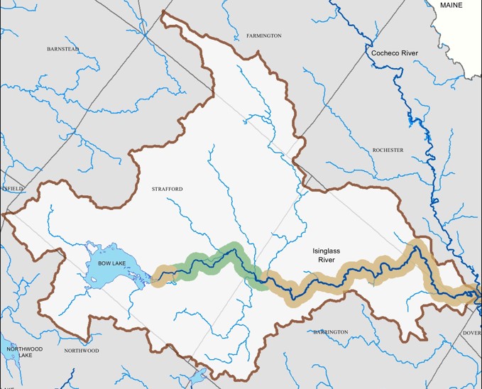
The protected instream flow study of the Isinglass River began in Summer 2023. The draft Protected Instream Flow Study Report is anticipated to be ready for public review in 2025 and the draft Water Management Plan for the Isinglass River will be developed thereafter.
Real Time Water Data
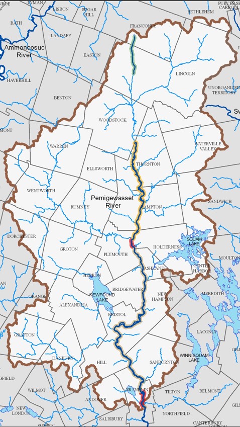
The protected instream flow study of the Pemigewasset River will begin in Spring 2024. The draft Protected Instream Flow Study Report is expected to be ready for public review in 2027. After that, the draft Water Management Plan for the Pemigewasset River will be developed.
Real Time Water Data
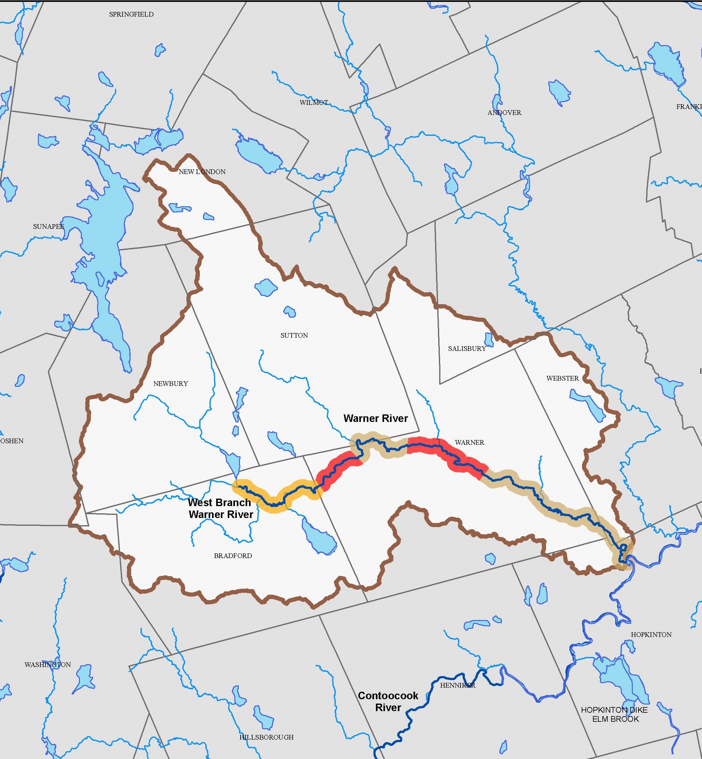
The Warner River was the subject of a Protected Instream Flow Study Report between 2021 and 2023. On September 25, 2023, NHDES’ Commissioner established the protected instream flow values included in the report as water quality standards, in accordance with Administrative Rule Env-Wq 1904. Release testing of dams within the Warner River watershed was conducted this summer to support the development of the Warner River Water Management Plan, which will occur over the next couple of years. 2023’s high stream flows interfered with this process and will be repeated next year during low flow periods. The public will be invited to Informational Sessions regarding this process as they occur.
Current Warner River Instream Flow Conditions (download)
Real Time Water Data
Protected Instream Flow Values Established – Flow Management Underway
The instream flow pilot study was completed in 2015 on the Lamprey and Souhegan rivers. The Report of the Instream Flow Pilot Program summarizes how the protected instream flows and water management plans were developed for each river, and makes recommendations for applying instream flow management on other New Hampshire rivers designated under the Rivers Management and Protection Program.
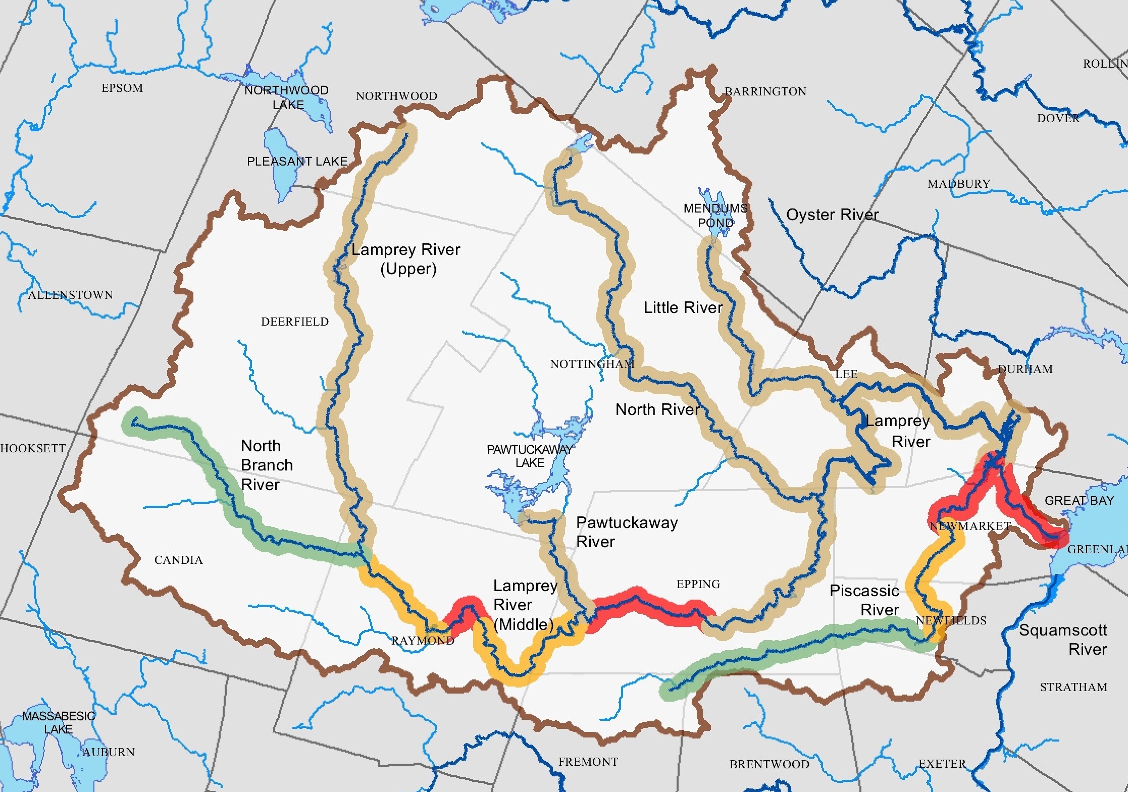 The lower Lamprey River was the subject of a Protected Instream Flow Study between 2005 and 2009. The upper Lamprey River and five tributaries were added to the Lamprey River designation in 2011, following the Protected Instream Flow Study. In 2013, NHDES’ Commissioner established the protected instream flow values included in the final report as water quality standards, in accordance with Administrative Rule Env-Wq 1904. The Lamprey River Water Management Plan was completed in 2013 and applies to only the lower Lamprey River. Between 2017 and 2021, Instream Flow Program staff collected environmental data from the lower Lamprey River to support long-term monitoring of aquatic and riparian ecosystems.
In Summer 2022, NHDES began collecting stream flow data from five designated tributaries (Little, North, North Branch, Pawtuckaway, and Piscassic Rivers) in the watershed, to support a future Protected Instream Flow Study of these designated rivers; stream flow data collection for the designated upper Lamprey River began in 2008. When sufficient stream flow data are available, Protected Instream Flow Studies will be performed for the upper Lamprey River and the five designated tributaries. The studies will be used to update the Lamprey River Water Management Plan to include the entire designated Lamprey River and its designated tributaries.
Current Lamprey River Instream Flow Conditions
Real Time Water Data
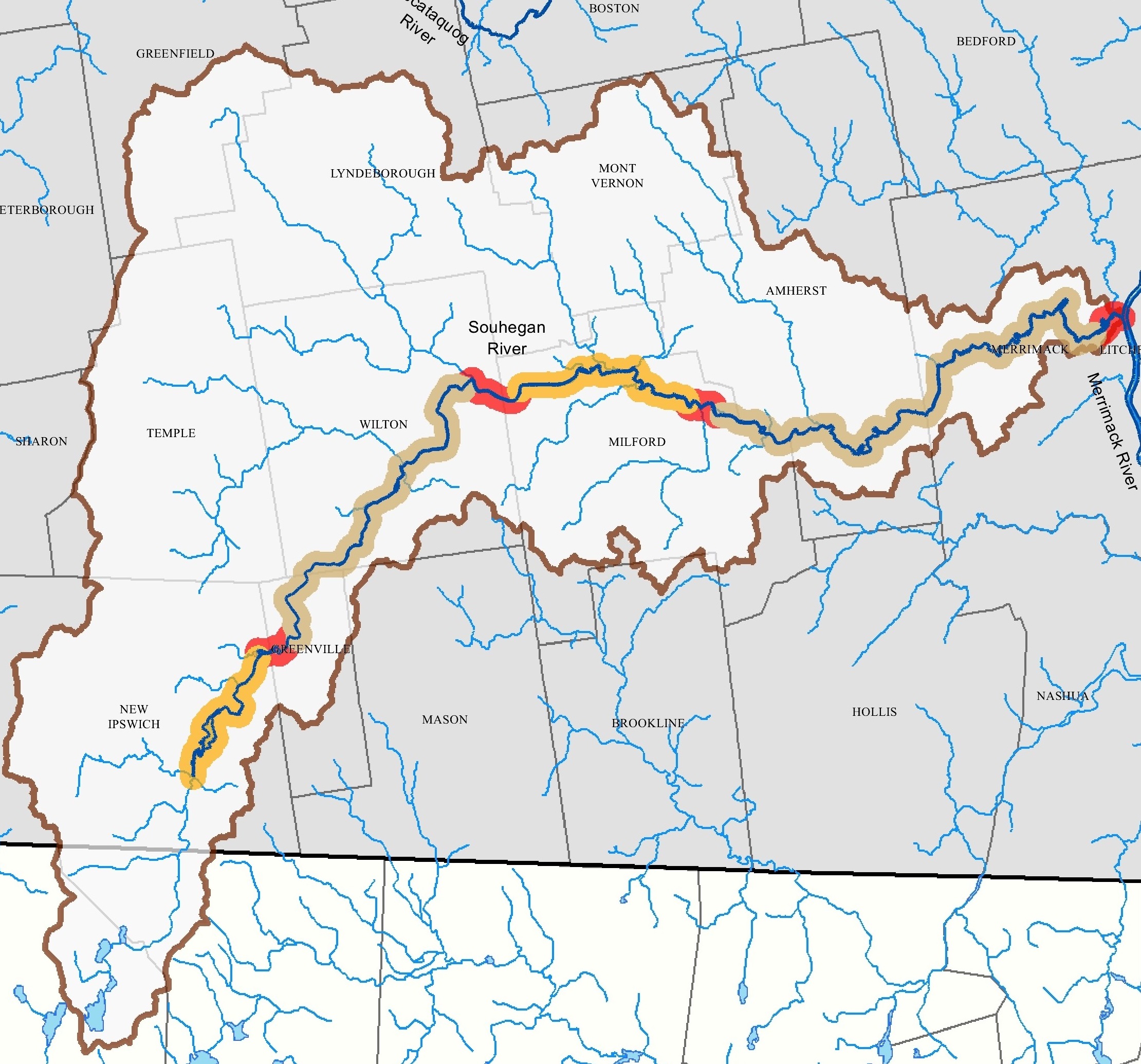 The upper and lower reaches of the Souhegan River were the subject of a Protected Instream Flow Study between 2005 and 2008. In 2008, NHDES’ Commissioner established the protected instream flow values included in the final report as water quality standards, in accordance with Administrative Rule Env-Wq 1904, which were slightly modified in 2013. The Souhegan River Water Management Plan was completed in 2013. Between 2020 and 2023, Instream Flow Program staff collected environmental data from the Souhegan River to support long-term monitoring of aquatic and riparian ecosystems.
Current Upper Souhegan River Instream Flow Conditions
Current Lower Souhegan River Instream Flow Conditions
Real Time Water Data
Future River Studies
Prioritization Ranking
In January 2023, following a series of meetings and public hearings, NHDES determined the Isinglass and Pemigewasset Rivers are the next designated rivers on which to conduct a protected instream flow studies. The 2022 Priority List is available for review. Please contact us if you have questions or comments regarding priority rivers for instream flow protection.
Real-time Stream Flow Studies
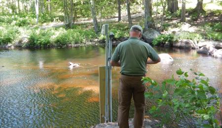
In order to obtain stream flow data to support future management of the designated Ammonoosuc, Contoocook, Exeter, Lamprey, Piscataquog and Swift Rivers, the Instream Flow Program has installed eleven near real-time water level stations along these designated rivers. To view the last 30 days of data from these stations, please use the following link to the NH Hydrologic Data WebMap. In order to view the streamflow stations data, open the Data Layer list, check the boxes to display the NHDES Streamflow Stations and NH Designated Rivers layers (feel free to hide other layers if it makes the map easier to read), and finally close the list by clicking on the X in the upper right corner. Clicking on a streamflow station icon opens its pop-up, where you can see details about the station, a photograph of the station and follow a link to a dashboard that displays near real-time station data.
Need more information?
Need more information?
There are five categories of Instream Flow publications available for your review:
- Planning documents (annual work plans, PISF study prioritization and other programmatic documents).
- QPPQ Transform Methods.
- Target fish community reports.
- Protected instream flow study reports.
- Water management plans.