

Commissioner's Column: Ambitious task pays off for stream flow protection
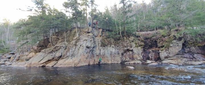
Just before Thanksgiving, the NHDES Instream Flow Program, assisted by members of the White Mountain Swiftwater Rescue Team, conducted the program’s most ambitious streamflow station installation to date, countering the Swift River’s high energy and wide range of flows by approaching the site from the side of a 35-foot cliff.
The Swift River station installation is the final of 11 stations installed during the past two years by the program. These stations provide essential stream flow data to support Protected Instream Flow Studies. The Instream Flow Program endeavors to maintain historical flow levels in the state’s 19 designated rivers, regardless of the uses and stresses that people put on them. A “designated river” is a perennial river that has been specifically nominated by a local New Hampshire organization or resident for protection under state statute RSA 483 based on its values and characteristics. If the nomination is supported by riverfront landowners and communities, the nomination becomes a bill that is voted on by the state Legislature and signed by the governor. The values and characteristics that support such designation include, but are not limited to: fisheries; geologic and hydrologic features; vegetation; wildlife; historical and archaeological features; open space and recreation features and potential; water quality and quantity; dams, hydropower generation, buildings, and other manmade structures; riparian interests and public water supply, including flowage rights known by the nominating individual or group, and other pertinent instream and riverbank and tributary drainage area characteristics.
Once a river is designated, it is first studied and its protected flow values are defined; then, a water management plan is created that ensures the protected flows are maintained while equitably sharing the water resources between water users, dam owners, and aquatic and riparian ecosystems. It is essential to this process to have current and historical stream flow data for each designated river, which is why this years-long effort to install these streamflow stations is counted as a major success.
The first step of this effort began in Summer 2021 with a pilot test of three types of water level stations to determine the best balance of features, reliability and cost. In June 2022, the program began installing 10 streamflow stations on the state’s designated rivers where existing stream flow data were insufficient or unavailable. Installation of the Swift River station completes this second step. The third and fourth steps of the task will focus on maintenance and refinement of the stations, as well as long-term management of the stream flow data collected.
Swift River Station
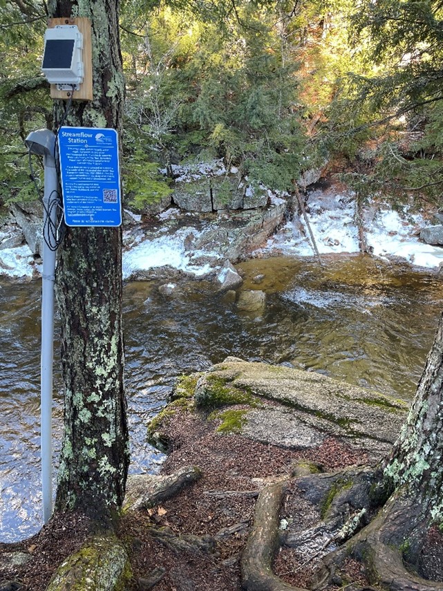 The Swift River station will provide near real-time (30-minute) streamflow data for the river, a half-mile downstream of Hobbes Brook in Albany, NH. In addition to providing important data for the Instream Flow Program, the gage is located on a stretch of river popular for whitewater kayaking and will be used by paddlers to determine if the river is safe to paddle. The station includes a stilling well that houses a water-pressure sensor, a staff gage where river level is measured, and a solar-powered water level station, which transmits the station’s sensor data wirelessly for reporting. After the exciting installation, program staff were amazed that they were able to find just enough wireless signal in the heart of the White Mountain National Forest. The selection of this location also continues the collection of steam flow data initiated by US Geological Survey (USGS) gaging station 01064485, operated in the same river pool between 2009 and 2011, allowing us to incorporate those data into the program.
The station is currently reporting preliminary stream flow data. Due to the limited data available at this time, Instream Flow Program staff will visit the station regularly over the next year to collect river height (stage) and stream flow measurements. These data inform the development of a more robust rating curve, which will be used to refine our estimates of stream flow based on river stage. The past 30 days of station data are presented on a near real-time dashboard accessible to the public. In addition, a sign installed next to the station includes a QR code linking to the dashboard.
Gaging stations
Thirteen of New Hampshire’s 19 designated rivers have one or more gaging stations maintained by the USGS or the NHDES Dam Bureau. The Swift River station represents a program milestone, commencing the collection of stream flow data on the last of the six designated rivers which lacked such data. Data will support future Protected Instream Flow Studies and heightened protection under the Instream Flow Program’s rules. The program’s streamflow stations provide near real-time streamflow data for the following rivers:
- Ammonoosuc River (Lisbon and Crawfords Purchase).
- North Branch Contoocook (Antrim).
- Lamprey River tributaries: Little (Lee), North (Lee), North Branch Lamprey (Candia), Pawtuckaway (Nottingham) and Piscassic (Newmarket).
- Middle Branch Piscataquog River (New Boston) and North Branch Piscataquog River (Goffstown).
- Swift River (Albany).
NHDES provides links to a dashboard for each station that shows the past 30 days of water temperature, water level and water flow, as well as current water temperature and flow.
A map of all 11 of the Instream Flow Program’s streamflow stations is available on the New Hampshire Geological Survey’s New Hampshire Groundwater Level Monitoring Web Application, which includes hyperlinks to the dashboards for each station. Click the “Data Layer List” button (top right corner) and select “NHDES Streamflow Stations” to see their locations; click on the station icon to find a hyperlink to its dashboard. The public can also scan the QR code on each station’s sign for the dashboard hyperlink.
The Swift River installation could not have been accomplished without the support of the following groups:
- Permission of the various federal, state, and private landowners to access site streamflow stations on their properties on an ongoing basis.
- The Lamprey River Advisory Committee, which provided funding for two of the 11 streamflow stations to be upgraded to hourly reporting in near real-time, rather than annual data reporting.
- The White Mountain Swiftwater Rescue Team, which assisted with the installation of the Swift River station and is upgrading this station to half-hour near real-time reporting.
- The NHDES’ Watershed Management Bureau Biology Section, which provided funding for water level station procurement as well as field equipment support.
- The New Hampshire Geological Survey, which has provided access to an acoustic doppler current profiler for stream flow measurements and technical assistance in posting streamflow stations on their New Hampshire Groundwater Level Monitoring Web Application.
For more information regarding the Instream Flow Program or to report issues with our streamflow stations, contact Wayne Ives, Instream Flow Program Coordinator, at Christopher.W.Ives@des.nh.gov or (603) 271-3548 or Joe Schmidl, Instream Flow Environmentalist at Joseph.Schmidl@des.nh.gov or (603) 271-3280. For more information regarding NHDES’ designated rivers, contact Tracie Sales, Rivers & Lakes Programs Administrator, at Tracie.J.Sales@des.nh.gov or (603) 271-2959.